SWMP - Surface Water Management Plan
The Flood and Water Management Act (FWMA) 2010 updated legislation to create clearer structures and responsibilities for managing flood and coastal erosion risk, it also established Flood Risk Management Authorities. These include the Environment Agency (EA), Lead Local Flood Authorities (LLFAs), water and sewerage undertakers, highway authorities, district authorities and Internal Drainage Boards.
Essex County Council (ECC) were named the LLFA, responsible for overseeing and managing the risk of flooding from surface water, groundwater, and ordinary watercourses in Essex. As part of our responsibilities, we are required to prepare and maintain a Strategy for Local Flood Risk Management and in planning for future flooding, we aim to gather a better understanding of surface water flood risk within the county.
The Surface Water Management Plans (SWMP’s) are key strategic documents that help the LLFA do this, highlighting areas where we can consider focussing our resources to reduce surface water flood risk within local communities.
Surface Water Flood Risk across Essex?
Along with other LLFA’s, Essex County Council are required to periodically report back to the Environment Agency, who are the national lead on flood risk, as to the status of surface water flood risk within the county.
This reporting is done through the Preliminary Flood Risk Assessment (PFRA), which provides information on a county scale and was last updated by ECC in 2017. The PFRA identifies Flood Risk Areas (FRAs), which are local areas where the risk of flooding is likely to be significant for people, the economy or the environment and consider all sources of flood risk (i.e. Coastal, River, Surface Water etc.). Both the probability and the impact, or consequence of flooding are considered in the classification. The latest PFRA (2017) identified 5 FRAs within Essex, as follows:
- South Essex
- Canvey Island
- Harlow
- Colchester
- Chelmsford
The Risk of Flooding from Surface Water Map (RoFfSW), last updated in 2013 provides information on a national scale and is used as an evidence base for the PFRA. The EA produced the RoFfSW map as part of their strategic overview role in England. The map provides information on flood extent, depth, velocity, and hazard in a range of events. These maps provide an indication of areas (not individual properties) that are at highest risk from surface water flooding.
The Surface Water Management Plans (SWMP’s) are a further development on this and provide more detailed information at a district scale. This higher resolution assessment includes improved hydraulic modelling and data collection (i.e. Topographic data, Drainage Networks etc.) to better reflect the risk of flooding to properties within the study area.
What is a Surface Water Management Plan (SWMP)?
Surface Water Management Plans (SWMPs) outline the preferred surface water management strategy and establish a more detailed long-term action plan to influence, planning, investments, maintenance, and engagement.
The SWMP studies in Essex are undertaken in consultation with key local partners who are responsible for surface water management and drainage in their area. Partners work together to understand the causes and effects of surface water flooding and agree the most cost-effective way of managing surface water flood risk for the long term.
The following benefits are achieved by undertaking a SWMP study:
- Increased understanding of the causes, probability and consequences of surface water flooding;
- Increased understanding of where surface water flooding will occur which can be used to inform spatial and emergency planning functions;
- A co-ordinated action plan, agreed by all partners and supported by an understanding of the costs and benefits, which partners will use to work together to identify measures to mitigate surface water flooding;
- Identifying opportunities where SuDS can play a more significant role in managing surface water flood risk;
- Increased awareness of the duties and responsibilities for managing flood risk of different partners and stakeholders;
- Improved public engagement and understanding of surface water flooding.
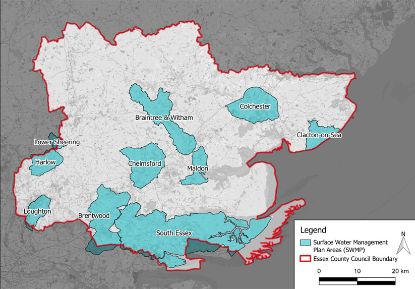
We currently have 10 SWMP studies completed within Essex. These include Braintree and Witham, Brentwood, Chelmsford, Clacton on Sea, Colchester, Harlow, Loughton, Lower Sheering, Maldon and South Essex*.
Further information
Surface water management plan technical guidance (2010)
The SWMP guidance has been written for local authorities to assist them as they co-ordinate and lead local flood risk management activities.
What is a Critical Drainage Area (CDA)?
The working definition of a Critical Drainage Area (CDA) in the context of the Essex SWMP studies has been agreed as:
‘a discrete geographic area (usually a hydrological catchment) where multiple or interlinked sources of flood risk cause flooding during a severe rainfall event thereby affecting people, property or local infrastructure.’
These areas have been defined by the hydraulic catchment, which is largely influenced by the topographical profile of the land. However, other factors such as local geology, surface roughness and drainage networks are also considered. This approach links the source of rainfall to the properties at risk of flooding via a critical flow path and enables surface water flood risk to be managed more holistically within a geographical area.
100 CDA’s have been identified across the 10 SWMP study areas and these are considered to act as a focal point for the LLFA when considering the implementation of measures to reduce flood risk.
How do the LLFA prioritise SWMP Studies?
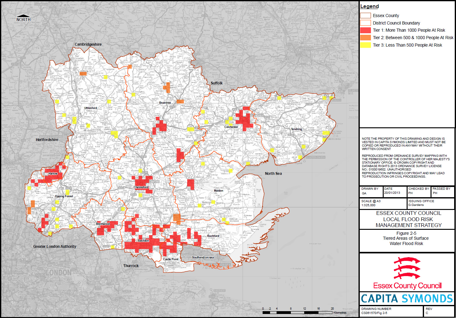
Whilst there are many properties at risk of flooding across Essex, it would not be possible to conduct detailed studies for each of these. As such, we need to identify which geographical areas have the highest concentrations of properties at risk off flooding and focus our resources accordingly.
To do this we use a Tier based ranking system, as follows:
- Tier 1 - Greater the 1000 People At Risk
- Tier 2 - Between 500 and 1000 People At Risk
- Tier 3 - Below 500 People At Risk
As things currently stand, we have completed detailed SWMP studies for all our Tier 1 ranked areas. We have not yet considered Tier 2 and 3 areas; however, that is not to say we will not do this at some point in the future. We aim to review the SWMP studies every 5 to 6 years, which coincides with the requirement to update our PFRA. However, there is no statutory requirement in terms of the frequency and need for us to do this.
When is a Property Considered to be at Risk?
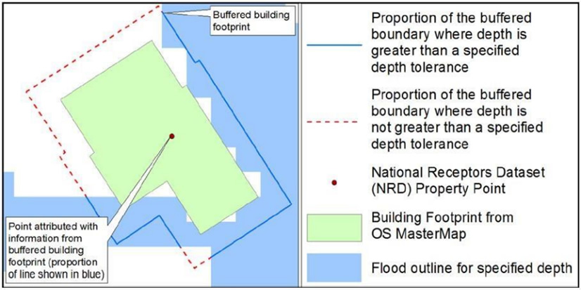
The Environment Agency prescribe an approach for estimating whether a property is at risk of flooding, that considers the depth of flood water against the percentage of the building perimeter that has been flooded. This is referred to as the ‘Wetted Perimeter’ method.
According to this method, a property is considered at risk of surface water flooding if the following criteria are satisfied:
- 50% wetted perimeter AND ≥ 0.2m depth threshold; OR
- 25% wetted perimeter AND ≥ 0.3m depth threshold.
Using this approach, the LLFA have identified around 8,700 properties at high risk of internal flooding across Essex during the 1 in 100yr rainfall event.
This increases up to around 36,000 properties when you consider those that meet the lower 0.2m depth threshold, but range between 0 – 49% wetted perimeter. Whilst the possibility of internal flooding remains high in these instances, the properties are more likely to have issues with flooding to external areas such as external buildings and gardens. We refer to these properties as being in ‘Areas at Risk of Surface Water Flooding’.
How do the LLFA identify and implement Actions to reduce risk of Surface Water Flooding to Local Communities?
There are various measures that the LLFA can consider to reduce surface water flood risk across Essex. These range from policy measures that influence how new developments consider flood risk by incorporating good quality Sustainable Drainage Systems (SuDS), to delivering physical infrastructure on the ground such as flood storage areas, Property Flood Resilience (PFR) and Natural Flood Management (NFM) measures.
When we know which areas are at highest risk of surface water flooding we can then look at what measures are best implemented to help reduce flood risk within those areas. It is important to note that we refer to ‘reducing flood risk’ as it may not be viable to protect properties in every situation. The SWMP study areas are assessed, and high-level measures captured within our SWMP Action Plans, for consideration. We currently consider measures in two tiers, those that can be implemented at a county wide level, such as policy measures; and those that can be implemented at a CDA level, such as flood alleviation schemes.
ECC have run a successful capital programme delivering flood alleviation schemes since 2015/ 16. Over the 8 years this has been in place, we have investigated more than 85 sites and conducted activities ranging from feasibility studies, through to delivery of flood alleviation schemes on the ground. This has resulted in around £24,500,000 of investment in flood risk reducing infrastructure, benefitting over 1600 residential properties across the county.
The SWMP studies and associated SWMP Action Plans feed into the capital programme. Having these strategic documents in place helps to secure both internal and external funding to deliver schemes that reduce flood risk to local communities, working with partner Risk Management Authorities (RMA’s) such as the Environment Agency.
Page updated: 12/09/2022