New Neighbourhoods Overview
The following rules are to be applied across all scales of New Neighbourhoods. Additional rules for individual scales are provided on the relevant subsections. Proposals must consider rules across all scales, in particular where developments are on the border between development scales.
Use Requirements
NP 2.1 Encouraged to include 5% Self Build / Custom Build Homes
NP 2.2 Minimum of 5% of properties encouraged to be suitable for an aging population
NP 2.3 Applicants should demonstrate that proposals are not reliant on the car for everyday journeys, including getting to workplaces, shops, schools and other facilities, open spaces or the natural environment. Compact forms of development that are walkable should be used to make destinations easily accessible by walking or cycling, rail, other public transport.
NP 2.4 Facilities clusters should provide coworking spaces to support home working, provision of food services (e.g. cafe) and toilet facilities
NP 2.5 The site must demonstrate provision of housing types that enable working from home with dedicated working space and fast broadband connections.
NP 2.6 Should consider non-residential buildings which offer a community benefit and are to be designed to incorporate multiple uses. E.g community hall, flexible workspace, cafe, pub etc. This is in addition to (or to be delivered alongside) local centres where required.
Movement Requirements
NP 2.7 All homes should be located within 10 minute walk of a bus stop (new or existing).
NP 2.8 Should demonstrate how the design of public transport and mobility infrastructure takes account of the DfT’s document ‘Inclusive Mobility: A Guide to Best Practice on Access to Pedestrian and Transport Infrastructure’
NP 2.9 Should demonstrate how the masterplan has incorporated the principles of Active Design Guidance: Activity for all, walkable communities, providing connected active travel routes, mixing uses and co-locating facilities, network of multifunctional open spaces, high quallity streets and spaces, providing activity infrastructure, active buildings, maintaining high-quality flexible spaces, and activating spaces.
NP 2.10 Must include a minimum of 1 car club space per 500 homes. Additional un-allocated spaces within streets should be reserved for future car-club use.
NP 2.11 Must be a maximum 20mph speed limit.
NP 2.12 Must not exceed parking standards. These must be taken as maximum standards.
NP 2.13 Must explore opportunities for car-free neighbourhoods and solutions such as remote parking barns to reduce car dominance.
NP 2.14 Outline applications must include a review mechanism for parking standards and reflect emerging policy within subsequent Reserved Matters Applications taking all opportunities to reduce car ownership.
NP 2.15 Where development is reliant on existing facilities to meet sustainability criteria, movement network must demonstrate efficient walking and cycling connectivity.
Nature Requirements
NP 2.16 Encouraged to deliver minimum 50% Green Infrastructure total.
NP 2.17 Equipped / Designated Play Space should be in accordance with Fields in Trust Quantity Standards.
NP 2.18 Informal Open Space should be in accordance with Fields in Trust Quantity Standards.
NP 2.19 Allotments and Community Gardens should be provided at 0.3ha per 1,000 population
NP 2.20 Every home should be within 2 minutes of open space
NP 2.21 Should provide nature-based sustainable drainage solutions (SuDS) based on the standards and principles in the CIRCA SuDS Manual and DEFRA;s non-statutory technical standards on sustainable drainage.
NP 2.22 Sites must provide community growing within all new neighbourhoods, linked to facilities clusters, in addition to allotment requirements
NP 2.23 Must deliver 10% bio-diversity net-gain in accordance with national policy. Large sites will be expected to target 20% Biodiversity Net Gain, delivered in accordance with mitigation hierarchy
NP 2.24 Should target provision 10% of the overall Biodiversity Net Gain on-site in line with the mitigation hierarchy.
NP 2.25 Should provide a landscape buffer zone of 50m to ancient woodlands.
NP 2.26 All streets must incorporate nature-rich green and blue infrastructure to connect people with nature, provide urban cooling and sustainably manage surface water.
Built Form Requirements
NP 2.27 All homes encouraged to be delivered to Building Regulations Requirement M4(2): Category 2 (accessible and Adaptable Dwellings)
NP 2.28 10% of market housing and 15% of affordable housing encouraged to meet optional Building Regulations Requirement M4(3) Category 3 (Wheelchair Users Dwellings)
NP 2.29 Buildings encouraged to have a net zero on-site energy use, with space heating limited to 15kWh/m2 and total energy use limited to 30kWh/ m2. This should be met entirely through on-site renewables such as rooftop PV
NP 2.30 Upfront emissions from materials and construction encouraged to meet at least an ‘A’ for upfront embodied carbon measured using the LETI Carbon alignment tool.
NP 2.31 The site encouraged to achieve net zero from a whole-life carbon cycle perspective through an Extended Whole Life Carbon Assessment covering materials (embodied carbon), construction, in-use energy, maintenance and demolition. The design should support this and consider the role of green infrastructure in carbon sequestration.
NP 2.32 A net-zero show home should be provided to demonstrate the characteristics of such a home and used as an education tool to teach new residents how to use any new technologies that might be employed.
NP 2.33 Development must demonstrate consideration of phasing in relation to existing settlement and delivery of commensurate infrastructure across each phase.
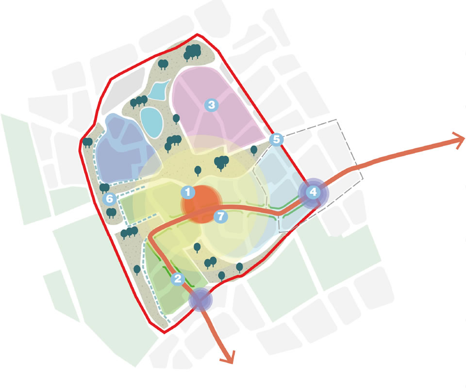
The below diagrams spatial present the development scale coding requirements for a New Neighbourhood, and the successful creation of place. This is intended for guidance only.
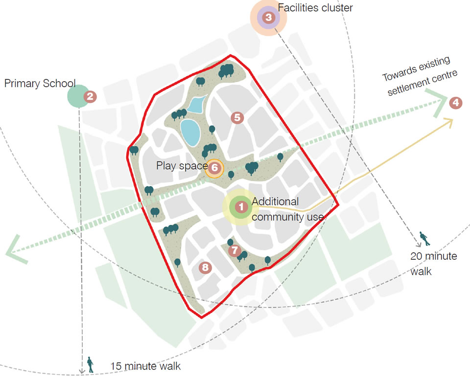
Use features
- A new use is located at the heart of the development, with a range of flexible uses
- All homes are within a 20 minute walk of the local primary school
- An existing facilities cluster providing for every day needs is within a 20 minute walk
- The town centre, including local employment, is accessible by sustainable travel modes within 20 minutes
- Focal spaces within each neighbourhood provide opportunity for neighbourly interaction
- A central equipped space provides facilities for all ages
- Community growing is integrated within the landscape framework promoting edible, healthy landscapes
- Homes for all ages are integrated across the development
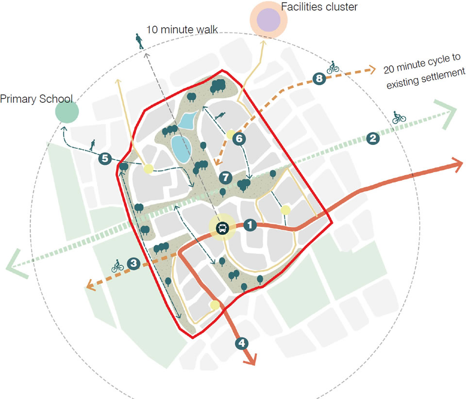
Movement features
- A bus route is provided through the site enabling all homes to be within 10 minutes of a bus stop. New community facilities are accessible by bus.
- The development integrates with the existing pedestrian route to deliver a key active travel route to the town centre
- New active travel routes connect people to the existing countryside
- Segregated cycle lanes are provided along key routes to promote safe, active travel
- Safe and direct pedestrian routes connect homes to the nearby Primary School
- A clear hierarchy of movement routes and spaces is created, connecting users to key spaces safely
- Key landscape corridors are designed to be low traffic and car dominance design out
- The development looks beyond its boundaries to promote wider opportunities to improve active travel

Nature and Public realm features
- A focal equipped play space is located within the centre of the scheme, within a generous green infrastructure framework
- Pocket parks and nodal spaces are interconnected through people-friendly routes and provide neighbourhood scale play
- An existing route is enhanced for pedestrians and cyclists and integrated within a landscape corridor retaining existing trees and hedges for biodiversity
- Opportunities to promote people and nature based connections with surrounding green infrastructure are maximised
- A new landscape edge is created creating a soft transition to the wider countryside
- The key destination space forms a focal point of the development
- A comprehensive network of SuDs maximises biodiversity and creates attractive focal features
Built form features
- Building heights increased towards the centre, focussed around new community uses and transport corridor
- Active frontages line the primary route with a distinguished frontage character
- Character areas provide differentiating characteristics which respond to local distinctiveness whilst creating a vibrant character for each new neighbourhood
- Key connections are defined through a built form hierarchy creating a strong sense of arrival
- Development structure responds to the existing block form and grain, creating a strong identity and integration with the existing place
- The new built edge to the surrounding landscape is responsive to topography and views creating a sensitive form
- A varied density is considered with increased density around key movement corridors and focal spaces
Page updated: 20/07/2023